Return to the AUH3 main page
Contact info and events Calendar on Hashes in the Gulf
and UAE
Calendar of runs in and near Abu Dhabi
this running season
Hash House Harriers in Abu Dhabi |
|
|
Site Name |
Directions |
|
Al Kubaira School |
Not hard to find if you can get the lay of the land. Go out Airport Road and turn right onto 17th St. This is mid-block between the traffic light at the "cheese grater" building on 15th, and before the bridge over 19th. Turn left at the elegant Sheikh Mohammed Bin Zayed Mosque. You will see St Anthony's Center just behind that, and the next parking lot is that of the school. The hashers are not always in this parking lot though. You may have to turn right on First St. and if the hashers are not in the parking lot to your right, you'll find them in the lot when you make the next right turn (in other words, drive around the school). Another way to get here is to drive from 19th St. toward town on Karamah. Turn right on First and look for the parking lots around the school (or right on 17th and follow directions from the Mosque). Or, go to the Ladies' Park next to Chouefat School on 15th just off Airport Road. Drive through the parking lot of the park toward the Mhmd bin Zayed mosque at the far end. Behind the mosque you will find a church. Behind the church, the school. |
| The Ally Pally | The Ally Pally (Al Ain Palace)
Hotel on what used to be the Corniche around the corner from the Royal Meridien
that used to be the Abu Dhabi Grande and the Forte Grande before that ... you
know, the one with the revolving restaurant on top. It's on the opposite side
of the road from the Sheraton.(if you park
there, take the footbridge under the road and jog over) |
|
This is on the Mussafah Road, on the LEFT side going out of town, near the turn-off (27th St. flyover, before the reviewing stands) which leads to Old Ski Club Beach. So heading out Mussafah Road, exit and cross the highway on the flyover, then head back ‘on yourself’ as the Brits like to say toward town on the Mussafah Road, keeping an eye out for the Coop now on your right. Another good way to reach here is to go out Airport Road, turn right on 27th (can’t recall what the landmark is here, but the Pepsi plant is at 29th, one traffic light further out of town), and just before the flyover, turn right again onto the Musaffah Road (the main highway) heading back into town. Here again, you'll soon see the coop on your right. |
|
|
Heading out of town on Airport Road, once you pass the first bridge (flyover, overpass) at Immigration (19th or Saada St.) slow down for the speed camera and then proceed to the 5th turning to the right. It is marked Al Nadha School. The hashers are usually visible within the first block or two. |
|
|
From downtown, head southwest up Electra / Zayed the Second toward Khalidiya where the street becomes Zayed the First. Turn left at the 32nd St. signal, the one after Khaleej Al Arabi. Take the first right off 32nd, which is marked with a petrol pump sign. It's called Thirteenth St. - but not to be confused, as Brendon once did, with 13th St otherwise known as Delma, which is far far away from here, as Brendon found out! The school is immediately on your left and the petrol pump on your left a little further on. Park anywhere between the two. It's on the map here: http://www.abudhabitriclub.com/map_hilton.htm If coming from Manhal St. (or from out of town) then turn right on (or come straight up) Baynuna and as you near the turn right on Thirteenth (but not 13th Delma!) which is, again, marked with a petrol pump sign. The school is on the right just before you'd have to turn right on 32nd. If coming from Manhal St. (or from out of town) then turn right on (or come straight up) Baynuna and as you near the Intercon roundabout turn right on Thirteenth (but not 13th Delma!) which is, again, marked with a petrol pump sign. The school is on the right just before you'd have to turn right on 32nd. (There used to be a water-resplendent and flag bedecked monument at the Intercon roundabout but at the moment its something of a construction zone, the monument having been knocked down by an overzealous tractor driver) If coming from the roundabout at the Intercon itself, don't use Baynuna, but head down Zayed St., take a right at the signal on 32nd, and turn right at the petrol pump sign. ACS is across the street on your left and you can do a U-ie at the Petrol Pump or if you want to warm up for the run, just park anywhere and walk across the road - BUT no parking near the American ambassador's residence. The guards will let you know if you need to move your car. |
|
| American International School | Not to be confused with American Community School in Khalidiya, AIS is off 29th St, opposite side of Airport Rd. to the Pepsi plant. To get there from Abu Dhabi, head outta town on Airport Rd, and when you reach the Pepsi plant on your right, turn left there onto 29th St. Then take the first right off of 29th and AIS should be there somewhere. Now in the case of Brendon, coming from Massafah, you turn RIGHT onto 29th St from Airport Rd and then your first right to get from AIS. |
|
Go down East Corniche, turn right at 31st. Street then double back on yourself shortly and follow the small road running parallel to east corniche into some open ground, and there will be signs from 31st street |
|
|
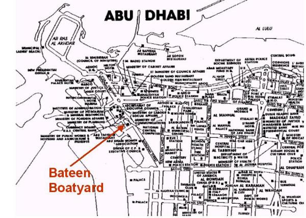
Bateen Boatyard |
We're not sure how to get here now. There is construction on the side of the road with the Tennis Court (actually an enclosed soccer pitch). Last time we were here, hashers found a dirt patch on the sea-side of the road and parked there. The instructions below will get you to the neighborhood: From the roundabout at the Intercon tennis courts take the road leading away from the Intercon until you reach a T junction (same as turning in toward the Intercon from the big fountain with the car park on your left, Intercon on your right, and taking a left at the tennis court roundabout before you drive into the water). At the T (water on your right, sand lot directly ahead), turn left and again immediate right. Just before you'd have to turn again (more tennis courts) pull in amongst the boats on your left. Or from the fountain r/a at the Intercon, come up Baynuna and turn right at the first traffic light. Go past the wall, behind which are the tennis courts. Turn right and you'll see the boats ahead on your right. It's just below the UAE Central Bank shown on this map: http://www.abudhabitriclub.com/map_hilton.htm |
|
It's in town, easy to find, easy to get a cab to. It's at 11th St. and 26th. The runners should be in the parking lot near the Shahama Grocery - the Coop is less obvious, behind the Shahama. 26th is between Karama and Khaleej Al Arabi, and 11th (sometimes called Defense Rd) is between Delma and Manhal. The US Embassy used to be on 11th in the direction of Karamah/Airport Rd, and the Wednesday predictor site is at the opposite end of 11th. You shouldn't have any trouble finding this one. |
|
|
Warning: This map has only oblique relation to what you find on the ground when you arrive in the area. The Mall (looks more like a bus station than a mall) is not off Baynouna Rd but off 32nd St, the road that in fact lies between Baynouna and Khaleej Al Arabi. If coming from KalA then you're ok if you go one block and U-Turn, but if approaching from Baynouna then turn toward Al Khaleej and you'll find 32nd St where it says Baynouna on the map below:
|
|
|
As you come down Mina Road (the road to Port Zayad) from the Sheraton / Salaam St, take the right turning at the stop light for the British Club, which might be signposted W&E Club. On the left there is a mosque, turn there (first immediate left) . You'll see the carpet souk at the end of the street, can't miss the carpets. The hashers will be in the parking lot. |
|
|
Follow the signs for Al Ain from Abu Dhabi. Just past the airport, you will see the Mafraq petrol station come in view on your right. The Mafraq p.s. is also called the "fort" p.s. due to its distinctive fake watchtower. If you see it in time, you should be about 2 km from it, and this is where you make a u-turn to head back toward Abu Dhabi. The turning for Boot Hill should be signposted to your right off the road back to Abu Dhabi just after you've doubled back at the u-turn. If you reach the fort petrol station, head back 2 km and take a right at the signs just past the place where you should have u-turned. This just in from Little Gem, Aug 2001: "the "U" turn normally used to get to "Boot Hill", "The Graveyard ","The Scrapyard" or what ever one calls it is now blocked off due to road works. Directions are-follow the road towards Al-Ain, after passing the Fort Garage, you will come to the Mafraq interchange, there are two choices here, the turn off to Liwa or Dubai. Take the turn to Dubai, and then once on the road immediately take the turn to Abu Dhabi, This is in effect a "U" turn using concrete bridges. Come back towards Abu Dhabi and there will be an MH3 sign at the turn off (On your right) with lots more directing you to the site. Alternatively you could go to Sweihan roundabout, turn right and when you get to the Mafraq interchange take the Abu Dhabi road. |
|
|
Get on Mina Road and drive toward the port. Turn right at the new traffic light on the road that takes you to the Club (fire station at that intersection, signposts to W&E Club). There is a lay-by 200 yards down on the right. Look for hashers there. Or, if the run is from the CARPET SOUQ then turn from Mina Road like you're going to the club, pass the W&E club on the first left hand bend then turn left at the street opposite and head back toward the main road (Mina Road) but turn off right before you get to it. That takes you into the carpet souq. I think now you can go past that light at the new (now old) traffic light and turn directly into the carpet souq from Mina Road. I'll check it out when I go there Dec 17, 2005. Meanwhile I'll follow these directions. We'll still get there. |
|
|
To get close, head for Baynuna Tower and aim for the park between the British Council on Al Nasr St. and the new improved corniche. (Hamdan St. turns into Al Nasr as you cross Airport Road where the huge white monuments are). If continuing from Hamdan St into Al Nasr, or turning from Airport Road onto Al Nasr and passing the Cultural Foundation on your left, turn right at the signal with All Prints on your left and Baynuna Hilton Tower on your right, and do a u-turn to the left before the corniche in order to park in the lot you'll see on your right as you come back up toward All Prints and Cafe Firenze. If coming from 26th, turn on Al Nasr (opposite Abela's) toward the British Council to All Prints, turn left, and u-turn to park in the lot aforementioned. If coming from the new Corniche, take the turning for Khalidiya and that should get you to the parking lot on your right at the park. |
|
Ali sometimes sets runs from this site near
his home. The area of town is shown on this map, just above the Bateen Airbase
marked Al Matar here:
http://www.abudhabitriclub.com/map_officers_club.htm |
|
|
Choueifat School is off Airport Rd between 15th and 17th Streets. Its carpark borders the huge carpark for the Ladies' Park where there is a Ferris Wheel. The hashers will be in the carpark for the school, or perhaps in the parking lot for the Ladies Park, if the venue is indicated for the Ferris Wheel itself. |
|
|
From the Hilton, if you stay on the Corniche Road, it doglegs right into Salaam St. at Mina Road (or “Port” Road, which takes you to the port). If approaching that intersection, you can’t miss the Sheraton Hotel though the turning to the hotel at the traffic light immediately on the Mina Road side is no longer there since the corniche was 'improved'. The Corniche Hospital is just behind the hotel, and to get there you work your way around as if to go to the hotel, but continue up the side street to reach the hospital. Traffic is one-way here, so navigating around the hospital is straightforward. Unless suffering the effects of too much on-on, hashers can bypass the main hospital entrance and continue to the back of the building. Bear left (the only way to bear) to find the car park where runs sometimes originate, or park in the last free parking space you can find to continue on foot to the club. If walking from such a space, the club is on your right as the road makes its last left turn to get back to the main hospital entrance, which is what you would do in your car in case you failed to follow these directions first time around. |
|
|
Crown Plaza Beach Club / Khubeirah Complex / EPICO parking lot |
The Crown Plaza beach club is between the Hilton And the Khaliyda Palace. Go out the Corniche between the Hilton and the new Hilton Beach Club and continue past the large picture of HRH Sheikh Zayed toward Ras Al Akdhar. Notice, across the road on your left, the building marked "Abu Dhabi" at the top and with EPICO in big yellow letters on its storefront. That's your destination (the defunct Domain club with it's distinctive onion dome is the next building over). The Domain is still indicated on the map here: http://www.abudhabitriclub.com/map_hilton.htm Make a 180 degree turn at the second roundabout (a left turn would take you into Khalidiya Palace Hotel at that roundabout). Coming back on yourself heading back toward town, get in the turn lane for a right turn before the Adnoc Complex toward the Intercon. The turning for the Crown Plaza Beach Club / EPICO store is in the middle of that protected right turn lane, signposted for Khubeirah Complex. |
|
This one is roughly at the new flyover at East Corniche (8th or Salaam St.) and Saada (19th). The best way to get here is to come up Airport Road to the Immigration bridge or just down from there on Maroor (4th) and turn going opposite the Higher Colleges entrance on 19th. Between 4th St. and the New Corniche, take the last right turn down the side street before the flyover at the New Corniche (with the Higher Colleges across the road on your left). Last time we were here, there was still a vacant lot on the left once you made that turn, but the lay-by where the hashers park had a freshly built villa blocking the view across the road, where the dolphins statue used to be just visible from here before the flyover was constructed. |
|
|
Proceed from town out Airport Road until you come to the second flyover before Emirates Motors (Mercedes-Benz). Get off at the r/a (don’t go over the flyover, but exit beforehand). Take the first right turn off the roundabout onto 33rd St. My guess is the cars and usual assortment of odd characters should be in one of the Exhibition Center public parking lots. The site is near the Heritage Village shown on this map here: http://www.abudhabitriclub.com/map_officers_club.htm You could also reach this site going out of town on Khaleej Al Arabi St direction Masafah Bridge until you pass the reviewing stands on your left (a bit before the Masafah Bridge). The Exhibition Center is just behind those stands, so exit right and take the flyover back over the highway, trying to work your way behind those stands. Still another way is to come out 4th (Maroor) all the way until it curves to meet the bridge at Airport Road. If you go straight under the bridge, the road becomes 33rd and the Exhibition Center is on your right. |
|
|
False trail!! On on to Choueifat School |
|
| MoI or Fourth and 15th | You can now get here from town by driving
out 4th and over the bridge at the end of Delma St (13th). The next signal is
15th, turn left there onto 15th and make a u-turn into the carpark on your
left. The Ministry of Information is around here somewhere. Another approach to this location is from 19th St. (Saada or Thanoon St, near HCT Men's College). From 19th St, drive on 4th/Maroor towards town. There is a right turn onto 15th from Maroor, before the bridge at 13th (Delma). If you're coming up the Eastern Corniche (Salaam St) either into our out of town you get off at the Saada St exit just before the bridge (either direction). Going the only way you can go from there HCT is on your right. Turn right at the signal past the college, which is 4th St. Turn right at the 15th St signal and make a 'u-ey' into the carpark on your left. |
| Giant Flag Pole or Heritage Village near Marina Mall | The giant flagpole is on the peninsula
opposite Marina Mall. From the Corniche, Hilton and Adnoc, go out the peninsula
to the last traffic light before the mall. At the light, turn sharp right and
Park near the flagpole in the Heritage Village parking lot. If we're running on
Lulu Island we meet here and catch the boat over from the docks to the right of
the Heritage Village. You pay 10 dirhams on landing at Lulu Island, and you can
use the buses on the island and ride the boat back when ready. They go pretty
much constantly in daytime. Here's a map of the area:  |
| behind the Grand Mosque | Consult this map:
http://www.abudhabitriclub.com/map_officers_club.htm You can reach the site by driving behind Carrefour and continuing past the Ice Rink (click here for directions to the Ice Rink) all the way to the end of the road where it now culminates in a T junction just behind the huge mosque, and U-Turn there and find parking on your right. You can also come here from the Officer's Club. Drive from the bridge over Mussafah Road with the mosque on your right till you reach the light, turn left, and park on your right. |
| Graveyard; see Boot Hill | Site used by the Mainland hash. Directions: Take the Al Ain Highway. Take the exit to Mafraq and Dubai Do a U-turn (signs to Abu Dhabi) Take the graveyard exit and Follow the signs. |
|
The helipad is on Mohammed bin Khalifa St. (15th) between Karamah and 26th (one way to get there is to come out Airport Rd. and turn right onto 15th at the "cheese-grater" building) . If coming from Karamah / Airport Rd., after the two speed bumps, make a u-turn and turn immediately right into the first car park you see. If coming from 26th, turn right into the car park after the palace gate which is just beyond the speed bumps that slow you down from your direction. A cab ride from downtown to this site would take ten min. but allow 15. |
|
| Gulf Hotel | Now pay attention here. This seemingly vital
landmark prominently situated just opposite the mainland between the Muqta'a
and Musafah bridges is feindishly easy to drive by, and road designers have
arranged it that you pay for that slipupwith a ten kilometer trip up the
mainland. It's easiest to come here from Airport Road. I think the hotel is
even signposted from this direction. As you approach the Muqta'a Bridge veer
right to remain on Abu Dhabi island and head toward the Musafah bridge,
counterintuitively traveling past the hotel.Before the bridge, the road comes
back on itself under the bridge and brings you the opposite direction down the
slip road from which you can reach the hotel. This is relatively straightforward compared to approaching from the Musafah Road. Assuming you can sus out the flyover you need to get on to swing you past the hotel, you'll notice that there is no way to jump lanes to actually reach the hotel from that direction, and you may infer that you want to bear right to pick up an access road taking you back to the hotel. WRONG. This sends you on the 10km journey into the desert, 20 by the time you've found your way back (take plenty of water on this journey). The trick is to bear left after bypassing the hotel so you pass under the flyovers and come back on yourself going once more past the hotel on the opposite side of the road where you go back on yourself again as mentioned in the above paragraph to gain the slip road from which you can reach the hotel. A paragon of planning, that one. |
|
Island Hash Beach (don't confuse this with Mainland Hash Beach, or Officer's Club) and I'm told it's starting to be called Twin Bridges City |
The site is on the beach across the channel opposite the Gulf Hotel between the Masafah Bridge and the Muqta Bridge. Access is possible from either bridge but much easier from Muqta Bridge (the Twin Bridges). Go from town out Airport Road and over the Muqta Bridge. Take the first possible turning to the right after the bridge which should be in the vicinity of a BMW garage, and work your way to the sand beach between the bridges. You can see a map of the area here: http://www.abudhabitriclub.com/map_officers_club.htm. And note rumour has it that in 2005 hashers have been discouraged from setting trails in this area due to the officers in residence here, we think. Roads change all the time here. One way to get there is come 'back on yerself' by turning right again after your right turn, follow the slip road back to the water, then head left over the sand where most traffic veers right to go under the bridge. Another way is (or used to be) head up the street leading beside BMW to the roundabout at the back of the garage. A paved road leads off the roundabout parallel to the water. There is a high curb preventing easy access to the sand except in two places. The first is right after the roundabout and is your best bet for beach access. To get to the second you have to follow the road some distance until it jogs left and watch for the pile of sand at the curb to the right of the first roundabout you come to. Either way, work your way to the beach between the two bridges and look for the cars parked on the beach. Some people without 4x4's park on the street and hike over to the beach. For the Wasps HHH, bring your cool-box along, since you'll likely eat there. |
| New Wasps Hash Beach | Cross the Muqta'a Bridge heading out of town. Get off at the first exit past the bridge. As you consumate the turn continue through the roundabout with the BMW showroom on your left. At the 2nd r/a, BMW just behind you on your left, go straight. Carry on straight through 2 more roundabouts before the road curves left away from Musaffah Bridge. You pass a beach on your right where the curb (kerb) has been freshly built up, blocking access to the beach until at the 5th roundabout you see enough dirt piled at the curb/kerb to allow you to get over it even in a salon car and park on the beach. Bring a coolbox with liquids for you and solids for the braai. You can see the lay of the land on this map showing the stretch between the bridges here: http://www.abudhabitriclub.com/map_officers_club.htm |
|
Go to the Hilton in Khaladiya, on the Corniche near the Intercon. At the back of the hotel there's a car park with hashers in it. Hemingway's is a pub and restaurant back there with a popular jazz bar. This is easy to find and easy to get to in a cab. It's just left of the roundabout to the right and behind the Hilton shown on this map: http://www.abudhabitriclub.com/map_hilton.htm |
|
| Hiltonia car park | Go toward the Hilton in Khaladiya, on the Corniche near the Intercon. Across the street from the front of the hotel there's a car park for the Hiltonia beach club on the corniche. This is easy to find and easy to get to in a cab. The Hiltonia is indicated on this map: http://www.abudhabitriclub.com/map_hilton.htm |
|
Head out Airport Rd. past the Pepsi plant and follow the signs to Zayad Sports City. After going over the second flyover (Carrefour), you'll come alongside the old in-town military airport. At the signal where you'd turn left into the (old) airport, you take the right sign-posted Zayad Sports City. On the side street, you pass a KFC on your left and come to a roundabout where you can only go right or left (gate to the Ice Rink straight ahead). Turning left, you'll see the cars in the car park for the big park across the street on your left, but you have to go way up the street and double back to get there (legally). If you're in a cab it's easier; just get out at the roundabout and walk across the street. Allow 20 min from downtown Abu Dhabi. You can also get here from Musafah Road. Go to the Officer's Club exit but cross the bridge going in the opposite direction from the Officer's Club and take the first left at the traffic light behind the Big Mosque. A couple of long blocks down, the park will be on your right. |
|
| Intercontinental Hotel | This is the tall hotel with the big I on it at the roundabout with the colorful cone-shaped fountain decorated in Emirati motifs. The usual meeting point is the 'tennis courts'. To get there, go to the fountain by driving on any of the streets approaching the fountain roundabout: Zayed the Second, or Electra, or Baynuna boulevard coming from out of town, or the back road from the Hilton or Baynuna boulevard from the Adco complex. However you get there, exit the roundabout toward the water keeping the hotel on your right. There's a big parking lot on your left, usually empty, where you can park, or there's also usually parking to the left of the small roundabout nearer the tennis courts. The roundabout is the little loop to the lower right of the Intercon on this map: http://www.abudhabitriclub.com/map_hilton.htm |
| Iranian Souq |
Drive down Mina Road toward the British Club, Port and Customs area, and Fish and Veg markets. Go to the intersection/traffic light before the port (police station on your immedate left, prominent white multistory building across the street on your left) and turn left (going straight would take you into the port). Drive past the big veg souq on your right and turn left at the first roundabout. The Iranian Souq is at the t-junction. |
|
From the Hilton Hotel, go down the Corniche past Khalij Al Arabi and look for the JC Penny building, Mercedes Showroom in the block before the park before Baynuna Tower. Parking is at the Mercedes end. |
|
|
The Jet used to be prominently displayed at the roundabout on Maroor or 4th Street beside the bridge on Airport Road near the Carrefour / Mercedes showroom. The jet is no longer there, but there remain 4 ways to reach this site by car. The Carrefour in question is indicated on this map: http://www.abudhabitriclub.com/map_officers_club.htm (1) Coming from the Muqta'a Bridge, when you see Carrefour on your left exit from the right lane before the bridge and simply turn into the car park on your right well before your right turn into the 4th St boulevard. (2) Heading out of town toward Muqta'a Bridge, exit from Airport Road before the bridge beyond which is the old Carrefour and Mercedes showroom. Follow the roundabout under the bridge until just past where you pick up traffic coming off Airport Road from out of town, make that right turn into the huge car park. (3) Suppose you're coming up 4th St. otherwise known as Maroor. Note that th St is not Positively 4th St at this point, but becomes 33rd St on the opposite side of the bridge and continues to the Exhibition Area and the reviewing stands on Masafah Road. But nevermind all that, follow the r/a under the bridge and see if you can work it out from directions (1) and (2). (4) Suppose you're coming from Musaffah Rd., on 33rd St as per Note in (3) above, and heading toward the Airport Rd bridge. Go straight under the bridge and just past where you pick up traffic coming off Airport Road from out of town, make that right turn into the huge car park. If coming by taxi, carry a printout of this page and every few minutes show it to the driver and point to the appropriate directions. When nearing the bridge on Airport Rd act anxious and pound on the driver's seat back. Just when you thought you knew where you were going ... sometimes runs start from the park at that roundabout ('park' in this sense being a place for strolling and communing with trees and wondering why there are no squirrels). Coming up on the roundabout from 4th St./Maroor just past where the road starts to curve you pass a petrol station on your right and between there and the roundabout you can pull into a lay-by and park your car. If coming by cab, tell the driver "Airport Road bridge at 33rd Street, not immigration bridge". Get the driver to exit at the bridge, go under it, turn down Maroor/4th, and drop you at the first bus stop. Runners will be in the parking area across the street. If coming up Maroor or 4th St, tell the driver bridge at Airport Road and have him drop you at the layby well before the bridge just past the gas station. Share taxis ply this route and they should be going to the bridge or beyond it, and drivers will in any event take you where you want to go for a small consideration. |
|
|
Right in town, easy cab or even jogging distance from the Hilton or Intercon ... At the intersection of Zayad St. (i.e. Electra or Khalidiya St.) and Khaleej Al Arabi there used to be a Lamcy's, now called Prestige auto showroom, and catycorner to that and Zadco housing is the gardens. So if you go down Zayad away from the Hilton toward Etisalat and cross Khaleej Al Arabi, then you pass in front of the gardens on your right, easily spotted by its gate with the miniature watchtowers. The hashers you're looking for could be in the small lay-by in front of this gate, or they could be in the larger parking area off the side street perpendicular to Zayed opposite the Golden Fork Restaurant on Zayed St. From this side-street parking, A&E is amongst the shops on the left in case you need that information. It's marked Khalidiya Park on this map, http://www.abudhabitriclub.com/map_hilton.htm, and the street you're looking for is the same one with Abu Habib Pharmacy. |
|
|
Take the Corniche road to the tip end of the island, past the Hilton heading west into the setting sun. At the 2nd roundabout after the Hilton, where you would drive through a barrier to enter the "women's beach" area (except that someone has already driven through the barrier, leaving it lying on the sidewalk in a twisted heap - it's been repaired and by now permanently removed by the time your read this!) you turn left instead, where it's signposted for the hotel. You can see it on the map here: http://www.abudhabitriclub.com/map_ladies_beach.htm Stop presses: Due to construction of the massive new Hotel complex, the barrier is gone and the whole area looks different day to day. The number of roundabouts is more or less the same. You figure it out. Just before the hotel entrance, look for hashers in one of the car parks. Get out, lock your car, and run around in your shorts looking silly for an hour or so. You can easily get a cab here. Allow 10-15 min from the center of town. |
|
|
Go down Electra (Zayed) St. toward the Intercon and cruise through the intersection at Khaleej al Arabi, passing what used to be a Lamcy's, now called Prestige auto showroom's on your right. Turn right just before the petrol pump and park where you can. |
|
| Ladies' Beach | Known among expats as Ladies' Beach because
of the women's center situated here, and as Ras Al Akhdar locally (green
headland), the hashers meet at the car park of the public beach right at the
end of the peninsula, which you can see at the top end of the Ladies' Beach
circuit on this Abu Dhabi Tri Club map here:
http://www.abudhabitriclub.com/map_ladies_beach.htm.
To get there you drive all the way out the corniche past the Hilton and keep going straight past the turning for Marina Mall (shown heading off the left of the map here: http://www.abudhabitriclub.com/map_hilton.htm) so you'll keep Adnoc on your left and pass the Khalidiya Palace Hotel on your left. At the next roundabout after Khalidiya Palace Hotel, just past the new huge hotel complex under construction on your right, turn right and proceed until forced to bear left. There will be a car park there with some dubious looking characters milling about. Simpler instructions are go all the way out the corniche, keep going past Khalidiya Palace and the new hotel, and take the first turn to the right, go to the end of the road, park, run. |
|
On on to the Ferris Wheel !! |
|
|
Island will be outside Mussafah (or however you spell it). Go to first traffic light in Mussafah and turn left. Go down road until you see signs for Hash-maybe 1-2KM. |
|
|
Head out of town over the Muqta Bridge. Take the turning marked Masafah (2nd exit). Double back over the flyover marked 'back to Muqtah Bridge'. The run site is to the right just after the flyover. Look for signs and if you're lucky, cars. |
|
|
Take Airport Rd. over the Muqtah Bridge or Khaleej Al Arabi over the Musafah Bridge and follow signs to Dubai. Just past the airport, you'll find the Suweihan Roundabout (you'll see the Suweihan Restaurant there). Don't go right to Dubai or straight to Suweihan, but go left to Mafraq. |
|
|
From Khalidiya (Intercon, Hilton) go up Khaleej al Arabi St. to 11th. Turn left on 11th and right into what is once again the garage, filling station, and petrol pump all rolled into one, plus a convenience store. Look for hashers in the car park opposite the villas on the left. Or if you come out of town on 26th St, turn right on 11th, u-turn at Khaleej Al Arabi St., and find the petrol pump as noted above. (If you continued down 11th from 26th past Khaleej Al Arabi, you would wind up at the New Predictor site). |
|
| Mercedes Showroom / Carrefour |
Proceed from town out Airport Road until you come to the second flyover over 33rd St. Get off at the first exit AFTER crossing over the bridge. At this point Carrefour looms on your left and if you turn in the parking lot to your right you should find hashers standing about in the empty spaces between there and the Mercedes dealership at the end of the lot. The Carrefour hypermarket is indicated on this map: http://www.abudhabitriclub.com/map_officers_club.htm You could also reach this site going out of town on Khaleej Al Arabi St direction Masafah Bridge until you pass the reviewing stands on your left (a bit before the Masafah Bridge). Take the flyover back over the highway onto 33rd St and you'll see the Mercedes dealership on your right just before the bridge and big roundabout. Coming from Musafah I'm told you take that turning onto 33rd just past Zayed Sports City (and if you reach the reviewing stands you've gone too far, so take the next exit right, turn right on Airport Road, and follow the instructions in the preceding paragraph. Still another way is to come out 4th (Maroor) all the way until it curves to meet the bridge at Airport Road. Go under the bridge. Bear left onto Airport road after you pass under the bridge and take the first exit right before merging with traffic on Airport Road. |
|
The Municipality is a huge building on 8th (or Salam St.). Sometimes the hashers meet behind the Municipality Bldg. Heading away from the Sheraton on Salam St, go a few blocks to the intersection with Toyota on the left-hand corner, turn right, and look for hashers in the carparks behind the municipality across the street on your left. The old Etisalat building, a white structure, is a landmark here, or used to be (not sure if it's there any more). The Salam St. carpark is in front of the Municipality Bldg. If you go past the front of the municipality, the next intersection has the Harley Davidson shop near the corner. There is a parking lay-by here, off Salam St., and sometimes the hashers meet here. Other times we turn onto 9th St from Salaam St, and use the car park on 9th, across from Harley Davidson. Here's a map to that one:
|
|
| Mushref Adnoc Station | Mushref Petrol Station - come into town on Mussafah Rd and get off at the petrol station just before Shakhbut St exit, or heading out of town on Airport Rd turn right on 23rd St just past the 19th St Bridge, go on through to Mussafah Rd., turn right and turn in to the petrol station. There's minimal parking at the fast food place and an overpowering smell of toilet here (interesting combo with grease-fried chicken, could be some connection). |
|
To get here, head out of town on Moroor Road, a.k.a. 4th Street. Past the19th St. HCT/Fire Brigade, at 21st, you will find a larger-than-life-size picture of a police officer across the street corner on your left whilst at that moment on your immediate right before the traffic light you will turn into the parking lot of the Mushraq Bank, the tall building cattycorner to the large policeman, and encounter numerous hashers thereby. |
|
|
New Medical Centre carpark |
New Medical Centre carpark is off Airport Rd. at Electra (Zayad St), behind Alphadata and Ford / Mazda showroom |
|
The "Predictor" is an Abu Dhabi Striders event held each Wednesday evening at around 6:15. You predict your time over 3, 5, 8, 10, or 15 km and the three to come in closest to their prediction win bottles of soured grape juice from A&E. The Site for this event is at the Menasir end of 11th St. Going down 11th from Airport Rd. past 26th and past Khaleej Al Arabi, you continue on through the 5-way roundabout and through the next roundabout (where a left turn would take you to the Old Predictor Site). You'll see a huge attractive mosque on your right, and a parking lot with hashers therein, and a strikingly gorgeous sunset over the Bateen Creek if you're there at the right time of day. The car park is indicated on this map here: http://waspsh3.wikispaces.com/file/view/new_predictor2.jpg |
|
Go out Mussafah (West) Road and past the
reviewing stand and the stadium complex on your left and just as you pull even
with the huge mosque at the last possible exit before the bridge follow the
blue signs for 'Corniche' and the brown one for 'Officers' Club' to exit right.
This takes you up the flyover, where you'll turn right toward the impressive
Officer's Club complex. The OC itself is indicated on this map:
http://www.abudhabitriclub.com/map_officers_club.htm You descend from the flyover to the roundabout in front of the Officers' Club. Circumnavigate the roundabout in almost a u-turn except just to the right of where you would go back over the bridge you came in on you see a two way street taking you alongside the bridge toward the water the bridge spans and to a recreational area with many car parks. Look for hashers in one of these. The Mainland Hash Beach used to be in this area (the Island Hash Beach is somewhere else). Nowadays an imposing gate is being built making this a dubious option: where you'd turn left to enter the OC, take the right opposite the Officer's Club and proceed with the water on your right away from the Officer's Club toward the villa with the gate and the flying saucer on top. Hashers will be seen near there parked on the right. Have a swim after the run. |
|
|
Old Predictor Site |
Go out of Abu Dhabi on either Airport Road or the Masafa Road (Khalij Al Arabi or Baynuna). Turn right at the light at 19th St, marked Saeed bin Thanoon (Saeed bin Thanoon the First nearer the beach). Continue to the end of the road past 30th and 32nd streets to the traffic light on 8th (the predictor route). There is a traffic light just short of the beach at this point. Turn left at the light (if you get wet, you've gone too far, and don't go right, which takes you to the New Predictor site). After the left turn make a u-turn first chance you get, just 50 meters up the road. The hashers will be standing about looking self-conscious in a sand lot opposite the beach, or if you're late, just their cars will be there. The site is just down from the Equestrian Center as you turn on to the beach as shown on this map: http://waspsh3.wikispaces.com/file/detail/oldpredictor2bonneez.jpg |
|
Come out Khaleej Al Arabi / Western St. past 19th. There is a long stretch with no major exit all the way to 27th where a fly-over crosses over the road (just before the reviewing stand). Take the turning to the right just after the flyover and proceed past the flyover exit over the bridge across the channel to the first junction where you turn left. You'll see the usual collection of vehicles and under-dressed expats in one of the carparks across the road on the left. You'll have to drive way down the road with the channel on your left, and with the reviewing stand visible across the channel from there. At the first opportunity, double back on yourself to find the carpark. You can also drive away from town on Airport Rd and turn right on 27th (one signal before the Pepsi plant on 29th). Once you've made the turn, you'll see the bridge ahead. Fly over, take the first right after the bridge (don't get back on the main road), and follow the directions from the junction above. You could do this in a cab, about 20 min. from downtown. For the Wasp HHH, bring your cool-box along, since you'll likely eat there. If following Harry's pathetic excuse for a map, ignore the street numbers indicated. You can also find the entry to the Ski Club beach shown at the lower left of the map here: http://www.abudhabitriclub.com/map_officers_club.htm |
|
|
Head out Airport Road and turn right on 29th. The Pepsi plant is right on that corner. You can't miss it. Behind the plant is a huge vacant sand lot. You'll find a chance to u-turn to it down the road on 29th. You can easily get here from the Masafah Road by turning toward Airport on 29th. You can also easily reach this site in a cab, about 20 min. from downtown. For some runs it’s more convenient to head through the light at 29th on Airport Road and turn right on the track just past the Pepsi Plant to get to the sand lot at the back of the factory. |
|
| Petroleum Institute, or Francis's Pump Station | To get here, drive heading out of town over the Muqta'a Bridge, exit right and come back on yourself back toward the water, continue right, under the bridge and then on the slip road up the other side so you're heading away from the water again, pass by Milco, the Sorbonne (that's right, the Sorbonne) and at the very end of the road you'll end up in the Petroleum Institute parking lot, which is where you should find a few other runners. If we're on on at Hibba's afterwards, bring a bathing suit. |
| Reef Palace | Head outta Abu Dhabi past the airport to the Suweihan Roundabout (Suweihan Restaurant) and take the Dubai road. After about 5 km you come to an interchange. Take a right turn off the highway at that interchange and immediately right again to double back on yourself, as the Brits so graphically put it (makes an American's neck crick just thinking about it). Then turn left and follow the signs. |
|
Proceed down Karamah Street heading out of town, except that you can't leave town on Karamah St. At the point where you can no longer leave town (at 19th, or Thanoon St), keep going straight up the cul de sac and follow your nose to the horses and hashers. You can also go out Airport Road, get off at the first bridge at 19th or Thanoon, and turn right past the Immigration building. The next traffic light is Karama, and you turn left into the cul de sac. You can get here easily in a cab; allow 15 min from downtown. |
|
| Sheikh Khalifa Medical Center | The Sheikh Khalifa Medical Center / Al Jazeera Hospital parking lot is at the corner of Karama Street and 11th. It's easy to get here in a taxi, or walk or jog from central Abu Dhabi. |
|
Sheikh Zayad Sports City |
Same as Ice Rink |
| Sheraton / Cornich car park | The new car park behind the Sheraton also
serves the corniche. On Salaam St. coming from Mina Road, turn in just before
the Sheraton (don't miss the turn or you'll have a long way to go through the
tunnel and back around in a circle) and then work your way on the slip road
past the hotel till it ends in the car park. Here's a road map of the area showing a typical run to a favorite watering hole. Normally we run along the corniche, not shown on this map:  |
|
Ski Club |
|
|
If coming from town, proceed out Zayed 2nd / Zayed 1st past what used to be a Lamcy's, now called Prestige auto showroom and past the traffic light on 32nd St. You come to a hill (unusual in Abu Dhabi) at the top of which is another traffic light (not unusual in Abu Dhabi). Turn right at the light, make a U-turn just past Spinney's across the street on your left, and turn right into the carpark. Look for a group of misfits. Easily done in a taxi, 10 min from downtown. It's marked Spinney's Al Khubeirah on the map here: http://www.abudhabitriclub.com/map_hilton.htm If coming from the Intercon down Zayed St. toward town, pass the roundabout and look for the big police station on your left. Next signal, turn left and U-turn after Spinney's. If coming from the Hilton, no telling what landmark mounds of construction rubble might be there one day to the next, but head toward town on the Corniche road or a road paralleling it, and look for Spinney's on your left. Turn, park, and run. |
|
|
Take Airport Rd. over the Muqtah Bridge or Khaleej Al Arabi over the Musafah Bridge and follow signs to Dubai. Just past the airport, you'll find the Suweihan Roundabout (you'll see the Suweihan Restaurant there). Don't go right to Dubai or left to Mafraq, but straight up Suweihan Rd, and count the gates in the fence on the left side of the road. Gate number 2 appears after a km or two across the divider. You'll have to u-turn at the first opportunity and double back down the road to the gate. Gates #3, 4 and 6 are further on, obviously. Hopefully, there will be signs. Allow about 45 min from Hamdan St. in downtown Abu Dhabi. Don't try this in a cab (or if you do, pay 20 dhms for a seat in a share van to Dubai, arrive at Suwiehan R/A early, and try hitching the rest of the way with hashers who will probably get to you before the police do). |
|
|
As of late 2004 TheOne has moved into town and its building has been taken over by Abu Dhabi University. There are other businesses in the area where hashers like to congregate. To get here drive over the Muqta'a bridge heading out of town. Take your first right after the bridge which puts you on a roundabout. For a description of this roundabout click here. To get to the old One, or ADU, or Milco, or Petroleum Institute (lots of places to set hashes here) you turn right at the roundabout so you are going back on yourself (I love that British expression, makes me think of a dog trying to lick himself ;-) so you are heading back toward town and the water you just crossed but you double back to your right (the American way of saying the above) under the bridge and keep to your right so you are heading again out of town but on the opposite side of the road you rode in on (another American expression). If your destination is Milco it's just on your left past the speed bump and stop sign (be careful here, cars exiting the highway have the stop sign but you have the speed bump, and guess which one has right of way). Other destinations will be further up the road. At the end of the road is the Petroleum Institute parking lot. If you get that far and don't see hashers, then double back on yerself and look more carefully this time. Be careful of traffic on this road. Dumpsters are set smack in the middle of one of the two lanes and it's a very congested area with huge industrial trucks backing unexpectedly into the other lane. Lots of cars will be driving in the parking lots, which have become defacto auxilliary lanes of traffic because of the dumpsters parked in the roadway. |
|
|
Drive down Mina Road toward the British Club, Port and Customs area, and Fish and Veg markets. Go to the intersection/traffic light before the port (police station on your immedate left, prominent white multistory building across the street on your left) and turn left (going straight would take you into the port). Continue through roundabouts past the souks and turning for the Al Dhafra Restaurant. Toys'r'us is on the left a few roundabouts down just past the industrial area access gate. If you come to a breakwater you've gone to far, but not that far past your destination (Mainland meets down by the breakwater, though). |
|
|
Go over Maqta'a Bridge. Take the first road off to the right, signposted Uum al Nar/Dubai/Shahama. The flyover bears left over the road you have just left. Turn right at the second road to the right, just before the Umm al Nar roundabout (should be the yellow Hash sign at this point - if not or not sure, turn anyway, as you won't get a second chance) and follow this road up for about 700m. Hash sign should then direct you off to the right off road to a small deserted white building behind which the cars are usually parked and from which the run sets off. This site is reachable in a saloon car. The on-on is generally then held near the cars. A cab to here might be possible, but will require all or some of language skills, charisma, chutzpa, and floos. |
|
|
Old directions, up to end of 2003: proceed to Shakhbut and 15th (Mhmd bin Khalifa) and park near the open ground. New directions: proceed to Shakhbut and 15th (Mhmd bin Khalifa) and ... uh oh, they've built a wall around it! Ok, turn up 15th heading toward Airport Road and take right at the roundabout (26th St) and you'll see HHHers on the left side of the boulevard. To reach them drive with the wall on your right to the roundabout at the end of the tree-lined center divider and u-turn to come back to the lot where the hashers are. Or head out of town on 26th St till it ends at the r/a on 15th. Continue on through the r/a and find the hashers on the left side of the boulevard. Do a u-turn at the end of the street, as far as you can go, to reach them. |


![]()
Use the BACK button or
navigation at top to return to a previous
page
For comments, suggestions, or further information on this page, contact Vance Stevens, page author and webmaster.
Last updated: October 6, 2008 06:00 GMT