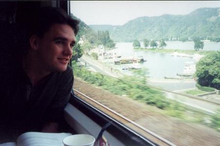
On the 12-hour train ride from Amsterdam, Glenn checks out a castle somewhere along the Rhine (around Bingen I think)
Glenn's writeup of the trip is here: http://www.geocities.com/glennaldo_sf/switzerland.htm
This page is a project of Vance Stevens,
http://www.vancestevens.com/
Return
to our Travel Pages main page
See what else I did with
Dusty and Bobbi in Texas this
summer
Vance and Glenn in
Scuol, Switzerland
July-August 2001
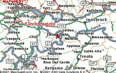
To trace the route from Amsterdam, click here
On the 12-hour train ride from Amsterdam, Glenn checks out a castle somewhere along the Rhine (around Bingen I think) |
Glenn's writeup of the trip is here: http://www.geocities.com/glennaldo_sf/switzerland.htm |
Tommy Back and his wife Alice and their daughter Anika are good friends of ours from when we all lived in Oman. Tommy was one of the best runners there, and we used to 'run across' each other when exercising in the open spaces across the highway from the university (Tommy would take his dog for a run, the same one in the photo below). Tommy recently moved to Scuol where he made the mistake of sending out one of those email messages to all correspondents describing how nice the place was and inviting all to come and visit. So Glenn and I went.
|
Here's a picture of Tommy, his dog Laiq, and Glenn and Anika, outside Tommy's house in Scuol. The fountain, one of many in Scuol, pumps spring water from the left spigot and slightly gassy mineral water from the right spigot. It's cold and pure, and if you're thirsty, you just carry a glass outside and fill up (preferably one with a splash of Campari in it). |
 |
Tommy is expecting lots of visitors as a result of his message, so the following is to describe what Glenn and I discovered during our visit there, which we hope can serve as a guide to others.
What we did around Scuol
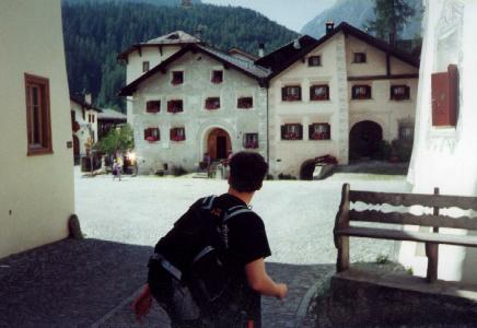 |
It's nice just to walk around Scuol, a small, pleasant, picturesque, and typically Swiss town with old houses. |
Motta Nulans
A good way to suss out the place is to take the pendicular up to Motta Naluns at 2146 meters and walk up to 2316 meters (didn't seem so far, but that was as measured by my GPS, just below the next higher ski lodge; looked closed, not sure) before following the yellow trail markers to Sent. The trail marker at the 2316 meter point says Sent is about 3 hours walking, which is about right, since it's downhill. It's a great high countryside trail with good views back to the peaks near the Italian border. You can plan your walks in those peaks with a good pair of field glasses. You can walk directly into Scuol if you don't want to go to Sent. If you do go to Sent, try to time your arrival so as to reach the restaurant on the way down to Scuol before it closes at 18:00 (we didn't make it, so don't know what kind of restaurant it is, but we were hoping for a place with a view to drink a pint - we were surprised at how few and far between such places are in this conservative canton). It takes about an hour to walk from Sent down to Scuol.
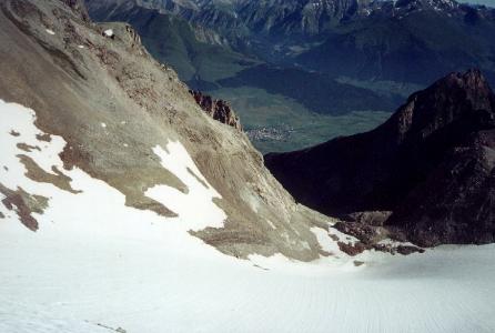
 This ticket gets you up the gondola to where you can walk down looking at views like this one. Chamanna Lischana is just below the snow in the glacial cut to my right, just visible with binoculars from here. That's Scuol in the valley below. |
 |
Plan de Fontana and Avorna and back to Scuol
One easy but scenic walk is to take the bus to Plan de Fontana and walk down the river to Scuol, but check the times on the buses. One bus stop is on the road to Plan de Fontana and San Jon over the high bridge, left at the tennis courts, past the camping, and 50 meters up the hill on the paved road where the Chamanna Lischana trailhead is. There are only a few buses in the morning up to around 11:00 and then no more until 3. If you miss the buses you can just walk up along the river. Just over the high bridge on the bank opposite Scuol, there is a trail map that will tell you the way to Vulpera and Plan de Fontana (and all the way to S-charl if you like). This trailhead is to the right of the soccer field and tennis courts as you walk away from Scuol.
| Here's the view from the high bridge, looking out on the church at Scuol and the low bridge over the En, which runs to Passau where it becomes the Danube. |  |
The walk down from Plan de Fontana should take a couple of hours. The river passes through a scenic gorge, with the trail following the rushing water. Halfway to Scuol, look for the trail to Avorna. It's a half hour walk up to the lodge, the high point on that part of the trail at 1400 meters, but you can get a beer there in pleasant surroundings, tables under umbrellas with views of mountains and sloping meadows (the waitress there was awfully nice - we'd ordered alcoholfrei beer by mistake as only the brand name was listed on the menu, and she took it back and replaced it with real beers even though she'd already uncapped the bottles). Retrace your way to the river and it's about an hour down to Scuol from there.
Glenn and I did this one starting from Scuol at 11:00, walking as far as the Avorna turning, and returning by 2:30, by way of Vulpera (not along the river). Having done it that way, it appears walking downstream all the way from Plan de Fontana would be most scenic and easiest.
Sur En to Uina Dadaint and on up the gorge
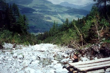
If you did do this gorge uphill like Glenn and I did, it would give you some indication of whether you wanted to do the walk up from Sur En, 1100 meters, which Tommy says you can reach from Scuol in half an hour along the river (looks more than an hour to me). Or you can take a bus, and from Sur En follow the road up the river for a couple of hours to the travelers rest in a farmhouse at Uina Dadaint at 1700 meters (Glenn and I did it in 1:15 coming down at forced march pace in order to catch a bus). The walk is along a gravel road that cars are prevented from traveling, though there are a lot of cyclists. You might want to be warned that there is no alcoholic beer at Uina Dadaint, and if you plan to drink apfelsaft (refreshing after a long walk!) and eat there, best bring your own sausage and cheese from the supermarket (and maybe a bottle of wine), because there is nothing special available to eat there.
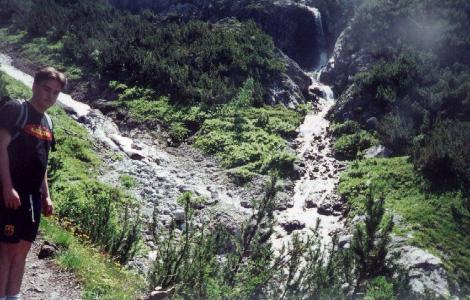
But the walk uphill from Uina Danaint is spectacular. It's ten times more difficult than the Avorna gorge walk, but more than ten times more scenic. The trail is carved out of the side of a gorge that falls away a hundred meters below. It leads from 1700 meters up to 2100 something and should take a couple of hours to reach the top of the gorge, where there are meadows surrounded by snow-swept mountains. Two rivers converge to feed the flow into the gorge itself. If you follow the trail along the river coming from the left you could eventually climb into Italy. If you follow the river up to the right you climb past some waterfalls and tarn pools to the S-charl trail fork at 2900 meters, and you can climb the peak of Piz Lischana at 3105 (takes a few hours to get to the fork, and an hour or more to the peak and back to the fork). Or at the S-charl junction you can go down to Chamanna Lischana and into Scuol, 1287 meters.
The baths
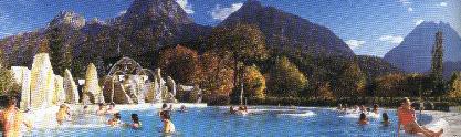 |
Glenn and I visited the spa our last day in Scuol, after we'd got down from Avorna. On that day the fountains in this pool were bubbling like jaccuzis, and we could see the hut we had walked to on the mountain slope high above. This picture is scanned from a tourist brochure |
Chamanna Lischana
Chamanna Lischana is a hut high up one of the glacial slopes in the mountains above Scuol. You can see the hut clearly from various vantages in Scuol. If you look up the right gorge to the south you can make it out on top of a knoll 1300 meters further up the mountain. From Scuol you can see it at about the same angle as in the picture below, so it's clearly visible if you know what you're looking for. One of the best of these vantages is the baths near Tommy's house, where you can soak in bubbling mineral water in the sunshine.
|
Glenn and I left Tommy's at 11 a.m. to begin our walk up to Lischana and we arrived at 4:30. We took it slow, pausing for example at this bridge to rid our packs of excess beer we happened to be carrying. |
 |
 |
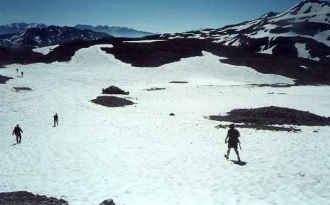
The walk went pleasantly up a snow-melt river but was tediously uphill and would probably be more interesting done coming down, where a walker would also face the best views looking back over the valley and the mountains on the other side. |
|
Here's what Chamanna Lischana looks like after 4 hours on the trail. Its altitude is 2500 meters (looks pretty good at this point, let me tell you - whew!). |
 |
Not everyone arrives at Chamanna Lischana on foot. The hut is supplied regularly by helicopter, so there is plenty of beer and wine and other beverages there. Dinner is served at 6:30, and breakfast 12 hours later. You can also get food prepared throughout the day if you just happen by.
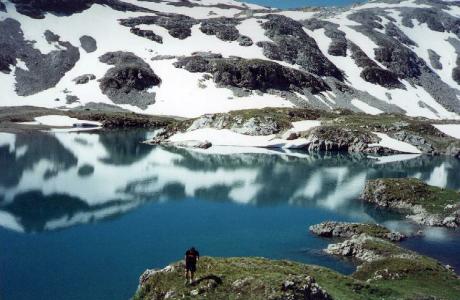
To do the walk downhill it would be better to reach Ch. Lischana from S-charl. That way you could bus up to 1800 meters, and the top part of the walk at 2900 meters would be done against a backdrop of snowy mountains on the Italian border. If you were ultimately going to Sur En then a drop down to Lischana would cost you 400 meters which you would have to retrace, only worth doing if you were going to spend the night there. Otherwise, you might want to just walk over to Piz Lischana from the S-charl / Sur En / Lischana yellow trail marker and continue on the Sur En trail once you got down from the peak. Then you'd pass the tarn lakes and drop down to Uina Dadaint via the gorge mentioned above.
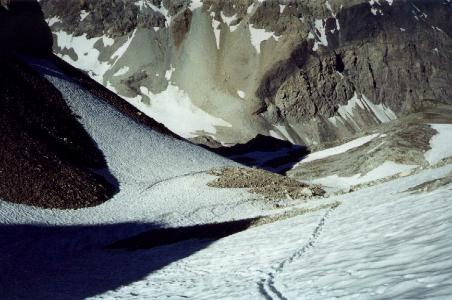 |
Glenn and I spent the night at Chamanna Lischana and started out from the refuge at 7:15 in the morning. The trail climbs for 400 meters, the last hundred meters through snow like this. |
| We reached the detour for the peak at 9:00 and left our packs where everyone else had left theirs. We walked up to over 3000 meters where we could see Scuol on one side and the Italian Alps on the other. | 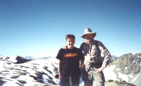 |
 |
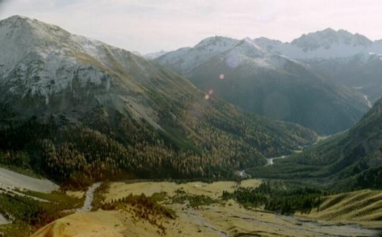
Looking north to Scuol in the valley, almost a kilometer below. |
| Looking south, S-charl to the right and Italy beyond the range at left. | 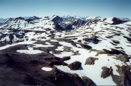 |
 |
On the downhill trail from the summit ... You need proper boots (well, Glenn, at right, was wearing tennis shoes, so much for that theory) and a walking stick might prevent a fall (a lot of people had them). There's a bit of snow in the mountains in August, and the walk at the high altitudes involves walking in not-insignificant snow patches. |
|
After another hour's walk, we stopped for lunch where Glenn swam in one of the tarn pools. On reflection (not the one in this picture) Glenn admitted this wasn't a 'cool' thing to do (bloody cold was more like it), considering where the water obviously comes from. |
 |
Another hour of walking over pleasantly descending snow hills and along a river that gathered volume as it descended got us to the fork in the river at the relaxingly spacious meadow you'd reach by walking up from Uina Dadaint. After the spectacular walk along the catwalk and tunnels carved midway up the gorge, we arrived at Uina Dadaint at 2:15 and left there at 2:45, to walk along a disappointingly tame (referring to the gravel road we were walking on) but still picturesque river swollen with snowmelt, arriving at Sur En at 4:00 where there was a bus waiting. We were told the last bus back to Scuol was at 4:45 and we'd hurried to make it. When we got aboard we found many others with whom we had shared the trail already there. They clapped for us as we boarded the bus (not sure what that implies).
| Some of our Swiss companions on the trail, with whom we had become acquainted at the lodge the evening before, took pains to point out the edelweiss growing in the rocks along the trail, which they said was seasonal and rarely seen. | 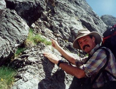 |
This page remains under construction until the last roll of film is removed from my camera, developed, and scanned.
This page prompted this response from a gentle 'local' (well, from Zurich) ...
Subject: your homepage
Date: Thu, 06 Dec 2001 00:31:37 +0200
From: Patrick Pfister <patrick@graffiti.net>
To:
vstevens@emirates.net.ae
Hello Vance
I stumbled accross your homepage rather coincidentally and got interested in the part about the Swiss mountains, esp. the "Chamana Lischana" Part. As I saw, you like to travel, I do as well. I'm pretty sure that you chose one of the best place in the mountains for hiking, since the view and everythings else is just exceptional in that area.
Since I am local (actually living in Zurich, Switzerland) I have gone to that are many times for the last 15 years. So, I know every stone up there :)
It was a good decision to go to "Chamana Lischana" from the "Scuol"-side. Because recently (in mid-November) I went from the other side (S-charl, going to Alp hut Sesvenna). The way becomes more and more steep. Finally, the way ended up in a boulder slope with no hint where to continue. It was so steep that you really needed proper boots, tennis shoes as Glen was wearing wouldn't have been good enough there. Some part of that route is so steep that it had to be equipped with security cable. Not to be recommended. The other way from the Italian side is pretty nice as well, but my favourite starts in "S-charl", going to "Alp Hut Sesvenna", turning right to the valley in direction of Italy, finally reaching the ridge, turning left again and after some steep hiking part, you can take a long and easy walk on the top of that mountain group.
Well, I enjoyed reading your homepage about the Swiss trip, and I am looking forward to see the "last role of film".
However, if you shoud ever plan to get somewhere in Switzerland again, or need information, do not hesitate to contact me.
kind regards,
Patrick
http://www.geocities.com/flying_patrick
P.S. Attached you find a picture that I took on the way to the top.
Amsterdam
When Glenn and I left Tommy's we traveled to Amsterdam and spent the night in the Roh Hotel. The hotel of course was only a refuge. Amsterdam was its usual charming self. We met up with Philip and Meiri Pinsent there. Phil is an old schoolmate of mine from University of Hawaii days, whom I had not seen since I visited with him in Papua New Guinea many years ago. We had a few beers at Amsterdam's charming sidewalk bars and a couple of oriental meals together in the course of an enjoyable visit.
|
|
For comments, suggestions, or further information
on this page, |
